aREAL® – The app for inner urban development
Mobile recording of internal development potentials
aREAL® is the first iPad app that professionally supports you in the digitization of inner development potentials.
No matter whether you want to take up your local inventory within the framework of an integrated municipal development concept or want to establish active space and vacancy management within the framework of an inner development strategy – aREAL® is your digital tool on site!
About the app
With aREAL®, the recording of vacancies, gaps between buildings, post-compaction areas and other inner-local potential areas is made more professional.
Municipal employees, local managers, student assistants or external service providers can work with the app without any problems.
INNOVATIVE
With our iPad app, you can digitally capture relevant object data directly on site, take photos and synchronize them with your potential area database.
EASY
Its simple operation makes aREAL® a valuable tool in the process of recording your inner-local potential.
PRACTICAL
You do not need an Internet connection for on-site data entry. The areas to be recorded can be uploaded in advance or created directly in the app.
EFFICIENT
Die Zuordnung von Objektdaten und Bildern zum jeweiligen Areal erfolgt direkt in der iPad-Applikation. Das spart Ihnen Arbeit und Zeit.
Unique functions
Working with aREAL® makes your data entry process more professional. Unique functions are available for this purpose.
With aREAL® you can
Development areas mobile recording
You can use the iPad to carry out the initial entry of the areas directly on site. The recorded information is available to you immediately and at any time in a clearly arranged digital form.
Run the app offline
You do not need an Internet connection to enter the areas. The captured images and the stored location information are stored in the app and can be accessed offline.
Synchronize with the online database
With an Internet connection, you can transfer the recorded data to the area database and, conversely, access data from the app that you have previously recorded on the PC.
Store location information
You can enter the address data of the recorded areas and call up and save the geocoordinates via the integrated GPS receiver. You can edit the stored data directly in the app via the map function.
Categorize area potentials
You can assign a recorded area to a category according to its development potential and mark the area as built-up or undeveloped.
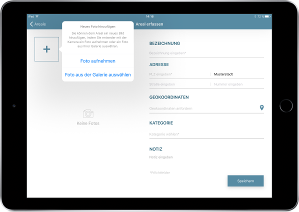
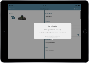
Take pictures
You can take any number of photos of the areas and link the pictures directly with other important information about the location and potential of the areas.
Digitize inner development
The development of a database for active space and vacancy management for internal development always requires the collection of data on site. At the latest during the marketing process, but basically already during the development of urban development concepts, photos and detailed information are required that cannot be retrieved exclusively from cadastral data and aerial photographs.
aREAL® simplifies the on-site acquisition process for you: you do not need an extra digital camera, you do not have to enter complicated images into your database afterwards and you can dispense with manual recordings.
Instead, with aREAL® you can rely on
standardised recording
Each area is recorded via a fixed input mask. This ensures that all necessary data for an area is stored in identical form.
easy entry
The registration of a new area takes place in a few steps. Images can be taken directly in the app and the geocoordinates of the current location can be retrieved.
optimized processes
The process of digitizing an indoor development area is significantly optimized with the iPad app aREAL. The application works smoothly with the aREAL software solution – the captured data can be synchronized as soon as an Internet connection is available.
clear, modern design
aREAL consciously focuses on a clear and modern design in order to concentrate on the essentials. All input fields and operating elements are designed for user-friendliness.
regular software updates
The availability of aREAL as an application in Apple’s App Store gives you uncomplicated access to the latest software updates.
professional support
aREAL offers an easy-to-use user interface that is self-explanatory in many areas. Should you have any questions or problems, please do not hesitate to contact our support team.
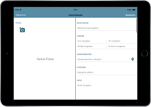
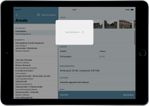
App screenshots: How aREAL® works
With the app you can register new areas on site. With a simple, clear entry mask you can save the data and photos of the areas. The initial entry also works in offline mode. The newly entered areas are saved in the app.
If you want to transfer the data to the online database, you need an Internet connection to synchronize. After synchronization, you can access the areas in the aREAL® software and edit them from there.
There is a list that shows all the areas entered, both the newly entered and the synchronized areas that are already available in the online database. Via the list you can access the individual areas in the app and edit their basic data.
Take a look at the App Screens to get a quick overview of the collection process.
FAQ: Your questions about
aREAL®
What is the purpose of the app and what is not?
The app is used for the initial registration of the areas on site. For the initial registration, certain standardized basic information on the areas is stored.
The app is not intended for entering more detailed information about the areas. You can, however, enter additional information and/or to-do’s in a note field.
The app is also not designed for the administration of the recorded areas. The administration takes place via your back office. There you can manage your inner development areas in an online database.
In order to be able to access the areas captured with the app in your back office, you must synchronize the app after it has been captured.
What happens during synchronization?
If you have created new areas with the app, the areas are initially only saved locally in the app on your iPad before synchronization.
During synchronization, the newly created areas are transferred from the app to the online database.
If you have created new areas in your administration area and then synchronize the app, you can also use the app to access these newly created areas.
Why do I need to sign in to sync?
Synchronization requires the existence of an online database with which the data from the app can be synchronized. This online database only exists if you also use the software solution aREAL.
As an aREAL user, you receive a user name and password as login data and thus have access to an individual administration area, your back office.
Before synchronizing, the app also asks you for your login data in order to first check whether you are an aREAL user. After successful login, the data from the app can be synchronized with your online database.
How do I get my credentials?
In order to receive the login data (user name and password) required for synchronization, you must be an aREAL user.
Which functions of the app can I use without registration?
Without registration you can use the app
- new areas;
- edit newly entered areas;
- delete entered areas.
Synchronization with the online database is not possible without registration.
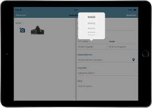
Which fields in the entry mask are mandatory?
You must make an entry in the mandatory fields, otherwise you will not be able to save the area.
Mandatory fields are:
- Designation
- ZIP code
- Location
- Category
In the empty, unfilled entry mask, the mandatory fields are marked with a *.
You can only make manual entries in the City and ZIP code fields before the first synchronization. The first time you synchronize, the app will be linked to your municipality’s data. The city is then fixed; the ZIP code has a selection menu with the appropriate postal codes.
How and where can I edit the captured images?
You cannot edit the captured images directly in the app.
To edit the images captured with the app, you must synchronize the app with the online database. After synchronizing, you can access the images and edit the photos in your administration area via the Areals.